
![]()
WP1 - Planning of the Deep Marine Environment and the Open Sea
Work Package (WP1) "Natural hazard and Earth Resources" consists of three themes - natural hazards, technological development and geo-resources. The main scientific results are:
AZ1 - Geological Hazard in Deep Sea.
Mapping of the main submarine geohazard features (scale 1: 50.000), highlighting cases of greater criticality. The most dangerous elements are submarine canyons whose heads may affect the edge of the shelf and in many cases (especially in southern Italy) dangerously reach short distance from the coast.
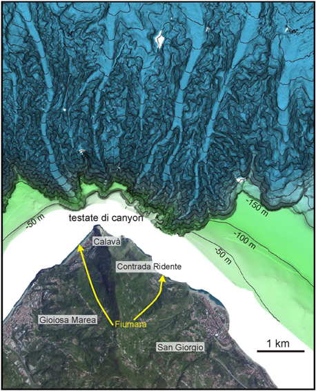 |
| Orthophoto and shaded relief of bathymetry of the area offshore Capo Calavà (Northern Sicily). A network of submarine canyons deeply incising the continental shelf is evident in he bathymetry |
AZ2 - Methodological progress in natural hazards definition in the deep sea.
Construction of two prototypes of OBS (seabed seismometers) with the aim to have, by the end of the project, low-cost modular instruments for active and passive seismology, and noise recording in the marine environment. Drafting of protocols for the characterization of offshore geohazards such as submarine landslide, submarine canyon and active fault. For the definition of volcanic hazards, the first dating of the modern type of the Marsili volcano was obtained. Dredged material from the steep NE margin of the edifice at about 3,000 meters deep gave an 40Ar-39Ar age of about 200 ka.
AZ3 - Earth resources and problems associated with their exploitation.
A regional inventory and resource mapping of critical areas of fluid emissions (hydrothermal and cold vents) in the southern Tyrrhenian Sea was realised trough the followings activities: analysis of stable isotopes (C and O) of aragonite/calcite and autigenic siderite of diapirs mud; XRF analysis on samples of autigenic mineralization from hydrothermal sites and cold vents; analysis of platinum metals (platinum, ruthenium, rhodium, palladium, osmium and iridium); XRF analysis of hydroxides crusts of hydrothermal vents and cold vents of the Basin of Paola; isotopic analysis of samples of native sulphur and pyrite.
A census and mapping of relict sand deposits potentially available for beach nourishment of eroding coastlines on the platforms of Lazio and Calabria was also conducted.
 |
| Upper panel: example of a gas plume observed in the water column using a multibeam system. Lower panel: 3D representation of the plumes superimposed on the bathymetry |
